File:The Bridge of Catzad-Dum map.png

Original file (950 × 1,100 pixels, file size: 225 KB, MIME type: image/png)
Summary
| Description |
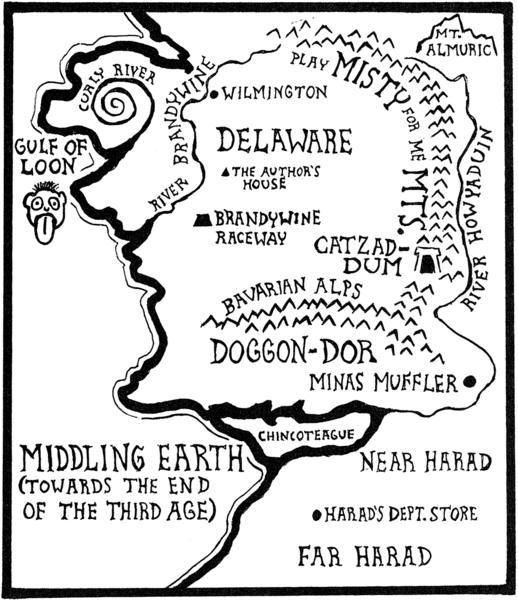
A map of "Middling Earth toward the end of the Third Age" showing the location of Catzad-Dûm and surrounding features. The map, a parody of Tolkien's Middle-earth, was created by Mark E. Rogers and published on the title page of the story "The Bridge of Catzad-Dûm" in his collection The Adventures of Samurai Cat. Other features on the map: Wilmington (and the author's house), Delaware, the Curly River, the Gulf of Loon (Lune), Brandywine Raceway (Brandywine), the Play Misty for Me Mountains (Misty Mountains), River Howyaduin (River Anduin), Mount Almuric, Minas Muffler, the Bavarian Alps, Chincoteague, Near Harad, Far Harad, and Harad's Department Store. |
|---|---|
| Source |
Scanned by Huw Williams (User:Huwmanbeing) |
| Date | |
| Author | |
| License |
It is believed that the use of this copyrighted item in Eamon Wiki qualifies as fair use under the copyright law of the United States. |
File history
Click on a date/time to view the file as it appeared at that time.
| Date/Time | Thumbnail | Dimensions | User | Comment | |
|---|---|---|---|---|---|
| current | 17:48, 8 August 2021 | | 950 × 1,100 (225 KB) | Huwmanbeing (talk | contribs) |
You cannot overwrite this file.
File usage
The following page uses this file: